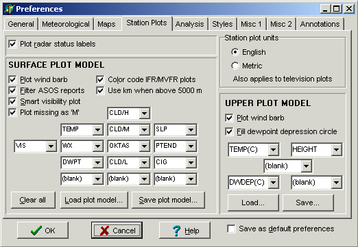
PREFERENCES PANEL
Station plots
tab
Also see the special topics on Surface plot models, Upper air plot models, and Station filtering. Station filtering has been moved to the Control Panel in Digital Atmosphere versions after 2002.
BASIC SELECTIONS
STATION PLOT UNITS
SURFACE PLOT MODEL
These settings only apply when the active level is the surface level and Overlay, Data is selected.
UPPER PLOT MODEL
These settings only apply when the active level is an upper level and plots are produced using Data > Plot.
PLOT MODEL CONFIGURATIONS
For both surface and upper air plots, a "grid" of dropdown boxes are set up in a way that represents the various data positions around a given station plot. You can use these dropdown boxes to adjust the kinds of data that are plotted in the different positions. Listed below are the different types of data that are valid.
Table of valid data plot elements. Units marked "C or F" or "ft or m" or "sm or m" are in metric or English according to File > Preferences > Station Plots > Station Plot Units unless otherwise specified here.
Blank) Nothing will be plotted in this
space
TEMP Air temperature in whole degrees
(C or F)
TEMP(10) Air temperature in tenths
(C or F)
DWPT Dewpoint in whole degrees (C
or F)
DWPT(10) Dewpoint in tenths (C or
F)
GUST Wind gust (kt)
RH Relative humidity (%)
MXR Mixing ratio (g/kg)
THETA
Potential temperature (deg K)
THETAE
Equivalent potential temperature (theta-e) (deg K)
WINDCHILL Wind chill
HEATINDEX
Heat index
SLP Sea level pressure (mb)
(plots tens, units, and tenths)
ALSTG
Altimeter setting (in Hg) (plots units, tenths, and hundredths)
WX Pictogram of current weather type
VIS Prevailing visibility (sm or m)
ELEV Elevation (ft or m)
CIG Ceiling (lowest layer occupying more than half of sky) (hundreds
of feet)
OKTAS Cloud cover in oktas
(eighths)
ID(ICAO) Station identifier
(4-letter ICAO)
ID(WMO) Station identifier
(5-digit WMO)
PCP01 Precipitation during
past 1 hour
PCP06 Precipitation during past
6 hours
PCP12 Precipitation during past 12
hours
PCP18 Precipitation during past 18
hours
PCP24 Precipitation during past 24
hours
PTEND Pictogram of pressure tendency
during past 3 hours
CLD/L Pictogram of low
cloud type
CLD/M Pictogram of middle cloud
type
CLD/H Pictogram of high cloud
type
CLDHGT Cloud height code (synoptic
only) (see chart below)
CLDAMT Cloud amount
code (synoptic only) (see chart below)
SHIPDIR Pictogram of direction of ship movement
SHIPSPD Speed of ship movement (kt)
SEATEMP Sea-surface temperature (C or F)
TEMPTYPE Type of temperature measurement
device
WAVEPD Period of ocean waves
(sec)
WAVEHGT Height of ocean waves (ft or
m)
SEAINSTHGT Instrument-measured height of
ocean waves (ft or m)
WINDPD Ocean wind wave
period (sec)
WINDHGT Ocean wind wave height
(ft or m)
SWELL1DIR Direction of primary
ocean swells (deg)
SWELL2DIR Direction of
secondary ocean swells (deg)
SWELL1PD
Primary ocean swell period (sec)
SWELL1HGT
Primary ocean swell height (ft or m)
SWELL2PD Secondary ocean swell period (sec)
SWELL2HGT Secondary ocean swell height (ft or m)
MINTEMP Minimum temperature (C or F)
MAXTEMP Maximum temperature (C or F)
GRNDSTATE Ground state code (see below)
INTERPRETING GROUND STATE CODES (GRNDSTATE)
0 Surface of ground dry
(without cracks and no appreciable amount of dust or loose sand)
1 Surface of ground moist
2 Surface of ground wet
3
Flooded
4 Surface of ground
frozen
5 Glaze on ground
6 Loose dry dust or sand not covering ground
completely
7 Thin cover of loose dry dust or
sand covering ground completely
8 Moderate
or thick cover of loose dry dust or sand covering ground completely
9 Extremely dry with cracks
10 Ground predominantly covered by ice
11 Compact or wet snow (with or without ice) covering less than half
of ground
12 Compact or wet snow (with or
without ice) covering half to less than entire ground
13 Even layer of compact or wet snow covering ground
completely
14 Uneven layer of compact or wet
snow covering ground completely
15 Loose dry
snow covering less than half of ground
16
Loose dry snow covering at least half of ground but ground not completely
covered
17 Even layer of loose dry snow
covering ground completely
18 Uneven layer
of loose dry snow covering ground completely
19 Snow covering ground completely; deep drifts
INTERPRETING SYNOPTIC CLOUD AMOUNT CODES (CLDAMT)
This category is defined as Nh; the amount of all the low cloud present, or, if no low cloud is present, the amount of all the middle clouds present. The figure is always in oktas (eighths). 9 is reserved for sky obscured by fog and/or other meteorological phenomena, and / is reserved for cloud cover being indiscernable for reasons other than fog or other meteorological phenomena, or observation is not made
INTERPRETING SYNOPTIC CLOUD HEIGHT CODES (CLDHGT)
This category is defined as "h, which is reserved for the height of the surface of the base of the lowest cloud seen. They are as follows (below). If the total sky cover is greater than 4/8ths, this figure is also transposed into the CIG slot, where they are plotted as "L" ("low cloud") followed by a loose translation of the table below in hundreds of feet. This "L" differentiates it from true ceilings where "C", "E", or "M" is prefixed.
0 0 to 50 m
1
50 to 100 m
2 100 to 200 m
3 200 to 300 m
4 300 to 600 m
5 600 to 1000 m
6 1000 to 1500 m
7 1500 to 2000 m
8 2000 to 2500 m
9 2500 m or more, or no clouds
/ Height of base of cloud not known, or base of
clouds at a level lower and tops at a level higher than that of the
station